Google Earth™ and the archaeological exploration of Afghanistan
David C. Thomas, Claudia Zipfel, Fiona J. Kidd und Suzanna Nikolovski
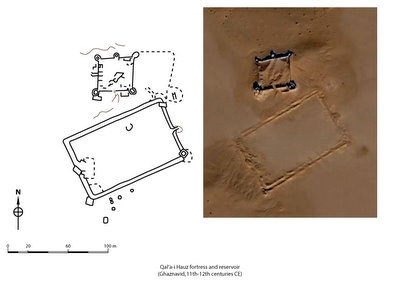
Fig. 2: Google Earth image and ASAGE plan of Qal’a-i Hauz - © ASAGE-Project
The archaeological exploration of Afghanistan has uncovered numerous remarkable sites, such as the Hellenistic city of Aï Khanum (Bernard 1982), and a dazzling array of priceless artefacts. A sample of these treasures was on display in European museums earlier this year and is now being showcased in the ‘Hidden Treasures from the National Museum, Kabul’ exhibition, touring the USA (James 2007; Zorich 2008). Our knowledge of Afghanistan’s archaeological heritage, however, is fragmentary – small parts of the country have been surveyed in detail (see French and German surveys in Sistan in the south-west, for example – Fischer 1983; Fischer et al. 1974-76; Hackin 1959), while large expanses remain virtually unexplored (Ball 1982: 21). This patchy coverage will continue to restrict the spatial analysis of Afghanistan’s archaeological remains for the foreseeable future due to the on-going violence in parts of the country and the dangers of unexploded munitions from the past thirty years of conflict. Consequently, archaeologists need to find alternative sources of data if they wish to investigate the nature and distribution of archaeological sites in Afghanistan.
Aerial photographs and, increasingly, satellite images offer archaeologists an alternative perspective on archaeological sites and landscapes. Good quality images, however, are often difficult or costly to obtain, although the recently declassified CORONA series of spy satellite images from the 1960s and 1970s provide a relatively inexpensive archive of snapshots of landscapes which have often been altered significantly by recent urban and agricultural expansion (Beck et al. 2007; Goossens et al. 2006; Philip et al. 2002; and Ur 2003, inter alia).
The launch of the ‘virtual globe’ Google Earth (http://earth.google.com/) in 2005 has transformed the way we view the world through satellite images (McCamish 2008). Google Earth provides high resolution images of selected parts of the world free of charge to anyone with a high-speed internet connection and this has excited the interest of thousands of ‘arm-chair’ archaeologists (Handwerk 2006). Although a few professional archaeologists were also quick to realise the potential of this new source of data (Beck 2006; Ullmann and Gorokhvich 2006; Ur 2006), most use Google Earth images merely to illustrate lectures and as a preliminary to fieldwork (Fleming 2008). Few researchers have published studies using Google Earth images (Petrie 2008 is a notable exception).
The Archaeological Sites of Afghanistan in Google Earth (ASAGE) project is an innovative attempt to use of Google Earth images as a source of archaeological data. High resolution Google Earth images cover 46,000 km2 (7%) of Afghanistan. Two hundred and fifty (19%) of the 1286 known archaeological sites in Afghanistan (Ball 1982) fall within high resolution Google Earth images. Of these, 217 (87%) sites lack even rudimentary plans. The ASAGE project has, therefore, decided to concentrate on three avenues of research:
-
to check the existing plans and descriptions of known archaeological sites and, where appropriate, to append details
-
to generate detailed sketch plans of unplanned known archaeological sites
-
to analyse high resolution images of unexplored areas in an effort to locate possible unknown sites
[1] David Thomas (e-mail: dcthomas@students.latrobe.edu.au) is entering the final year of his PhD on the archaeology of medieval Central Asia at La Trobe University, Australia (http://www.latrobe.edu.au/archaeology/). Claudia Zipfel, who finalised the German translation of this article and works on the project as a cartographer, is also a PhD student in the Archaeology Program at La Trobe University, while Suzanna Nikolovski is an undergraduate in the same department. Dr Fiona Kidd is a post-doctoral fellow at the University of Sydney. The ASAGE project research is funded by a grant (to Dr Alison Gascoigne, University of Southampton) from the Cary Robertson Fund, Trinity College, Cambridge.
© ASAGE-Project - David C. Thomas, Claudia Zipfel, Fiona J. Kidd und Suzanna Nikolovski
© ASAGE-Project - David C. Thomas, Claudia Zipfel, Fiona J. Kidd und Suzanna Nikolovski